This is a major release.
New Features
-
It is now possible to add Index 3D Scene (i3s) and GeoJSON layers, in addition to the existing layer types KML/COLLADA/glTF and Cesium 3D Tiles.
-
Existing thematic data embedded within the 3D layers themselves can now also be extracted and displayed, in addition to the already available options to include external thematic data using PostgreSQL/PostgREST and Google Spreadsheets. These layers include Index 3D Scene (i3s), KML, Cesium 3D Tiles, and GeoJSON.
Note: Due to the inconsistent labelling of object identifiers in Cesium 3D Tiles from various providers, the following approach was used for querying:
- Different identifier names are considered, such as
gml:id,gml_id,gmlid,gml-id,id, etc., regardless of whether the letters are given in uppercase or lowercase. - The same also applies to the column name of the identifiers in PostgreSQL/PostgREST and Google Spreadsheets, as long as the column names are valid.
- Different identifier names are considered, such as
-
In addition to embedded data and external PostgreSQL/PostgREST and Google Spreadsheets, OGC Feature API is now also supported as another external thematic data source.
Note: Due to the different implementation of the API across regions and countries, the current version provides some examples for handling the OGC Feature API implementations provided by the German states of Hamburg and North Rhine-Westphalia.
-
Web Map Tile Service (WMTS) can now be used as another imagery or base map layer, in addition to the existing Web Map Service (WMS).
Improvements
-
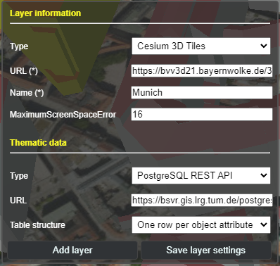
The Graphical User Interface (GUI) for adding and configuring layers in the toolbox have been rearranged to provide more clarity and consistency. The input elements are now grouped into two groups based on their functions for the selected layer type: layer information and thematic data, as shown in the example below:
-
Mobile support for geolocation has been completely reworked to adhere to modern security rules on personal devices, especially for iOS 13+. The new button icons and their functions are explained as follows:
From left to right: Default button, "snapshot" of location and orientation, live tracking of orientation (with fixed location), live tracking of orientation and location, and button for disabling geolocation.
-
The highlighting and hiding functions have been reworked, so that objects from across different layer types can be displayed correctly and consistently together.
-
Cesium 3D Tiles can now be navigated together with Google Street View, Dual Map View, etc.
Change Logs
For a complete list of all changes made for this release, please refer to the change logs.
What's Changed
- Adds maximum screenspace error option by @mulfvik in #78
- Merge from master to branch by @Son-HNguyen in #79
- cesium-1.117 by @Son-HNguyen in #80
- Update RELEASES.md by @Son-HNguyen in #81
- Release 2.0 by @Son-HNguyen in #82
- Release 2.0 by @Son-HNguyen in #83
- Update branch by @Son-HNguyen in #84
New Contributors
Full Changelog: v1.9.1...v2.0.0


