Python library to process mapant data to e.g. garmin custom maps
Most garmin gps support the CustomMap input type where you can add a raster images to your GPS. Raster image means that you have an image background but no points to e.g navigate to. For this you will need an img format like available from OpenStreetMap (OSM) via e.g. http://www.frikart.no/index.html
The mapant project available at https://mapant.no provides the possibility to download any area in Norway as png file and a world file with suffix .pgw. Those two files are expected as input to this package.
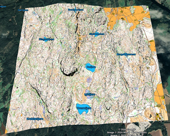
Example of a kmz file generated from the example data and visualized in google earth.
The result kmz file can be uploaded to your garmin GPS in the /GARMIN/CustomMaps folder. See alsp step 14,15, and 16 in https://support.garmin.com/en-US/?faq=cVuMqGHWaM7wTFWMkPNLN9
ImageMagick https://imagemagick.org/script/download.php
This package is available from pypi with the python pip intallation command
pip3 install mapant
Or in a local user installation:
pip3 install --user mapant
Get data to test on. For example from the examples diectory (by wget or simply download the data).
Run the generation
mapant2kml -w mapant-export-211859-6656711-215781-6660648.pgw -i mapant-export-211859-6656711-215781-6660648.png -o examples/Example.kmz -nx 4016 -ny 4031 -dx 1536 -dy 1536
See also the unit tests in tests directory
User guide mapant2kml on windows
Open prompt:
- Windows key + x
- Run (kjør)
- Type cmd.exe
- Type python
For me a Windows Store window popped up Install the free app for Python 3.8
See also https://phoenixnap.com/kb/install-pip-windows (PIP is the Python repository package)
- download https://bootstrap.pypa.io/get-pip.py
- run “python get-pip.py”
python -m pip install mapant
So where is it installed? Try running: “pip3 -V” This will show you the pip installation. The mapant2kml script is installed in the Scripts directory in the same location structure. See also example part.
Mapant2kml has (at least for now) one external dependency in the convert program from ImageMagick (https://imagemagick.org/script/download.php) (free, open source)
Install one of the installations, e.g. ImageMagick-7.0.10-35-Q16-HDRI-x64-dll.exe
NB! Tick the box about legacy utilities (convert) which is NOT ticked by default
Now we are ready to run the example from https://github.com/trygveasp/mapant#examples. Download the data and run mapant2kml as described.
Install google earth open Example.kmz which we generated You should get the example map shown above.
There is plenty of room for improvement in this windows tools by experienced windows user unlike myself. Please come with suggestions on how to thing different and in a simpler way.
