Welcome to the Fundamentals of Geographic Information Systems (GIS) course! This is an open course developed by Tampere University meant to get you started with GIS and give you the ability to work with GIS independently.
This course can be completed independently, or as a student at the Tampere University. Everyone is able to access the course materials and support, with the exception that students have to complete a number of criteria and if they do so, they are eligible for ECTS credits.
After completing the course you should be able to:
- Understand the fundamental principles of GIS, including rasters, vector, projections, geoprocessing and analysis
- Apply basic GIS skills to:
- Map Design
- Gathering GIS data from various sources
- Use different types of spatial data
- Analyse GIS data to address geosptial problems and/or research questions
- Develop the ability to perform new analyses, troubleshoot, and find help from the GIS community to solve your problems
The course consists of 9 exercises, each accompanied by a piece of theory. It's recommended to go through the theory before attempting the exercise. The first exercise is meant to give you the basic skills in GIS and the software we will be using, QGIS. From there on you will build on these basic skills using the other exercises, covering various analyses and methods, and develop a fundamental skillset in GIS and QGIS.
| Exercise | Topic | Methods |
|---|---|---|
| 1 | Crash Course | QGIS interface & Vector analysis |
| 2 | Vector analysis introduction | Digitizing, georeferencing, clipping |
| 3 | Socio-spatial differentiation | Raster analysis |
| 4 | Finding the optimal location for a new development | Buffer analysis, overlay analysis |
| 5 | Determining optimal land for cultivation | Digital Elevation Model (DEM), slope, hillshade, overlay analysis |
| 6 | Understanding disease transmission | Heatmap analysis (Kernel Density), Voronoi diagram, text processing |
| 7 | Air quality analysis | Spatial interpolation |
| 8 | Calculating building efficiency | Expressions, creating grids |
| 9 | Wind power NIMBY (Not in my backyard) analysis | Public Participation GIS/SoftGIS, Directional Distribution |
To get the credits for this course, the following criteria have to be met:
- Submitted original map output(s) for each exercise
- With your name on the output
- Submitted original map reflection for each exercise
- Completed the Moodle exams
To ensure that your submissions are original:
- Map output: Your name has to be mentioned on the map output and they will be compared with others
- Map reflection: Anti-plagiarism tool is used
If you ever have a question or run in to an issue along this course, please follow the following troubleshooting process:
- Start by checking if the information in the course materials provide a solution, it might have been covered in the previous theory or exercises as well
- If you come across missing information in the materials, please let us know so we can make sure others don't run into the same issue!
- Being a Professional Google Searcher will get you really far with (Q)GIS. Try searching your question or issue, below you can find some tips on how to improve your google searches
- Ask your question in the chat, other students or professionals will be able to help you! Use the channel of the exercise you are working on.
- If at this point you still have not found a resolution, you can ping the teachers in the channel with @teachers
Following this process will help you develop the independent troubleshooting skills you will need when you use GIS on your own.
This is where you will find the course content (theory and exercises) as well as the required data: https://github.com/rowan8k/fundamentals-of-gis/tree/master/Content
It is is recommended that you use Github in light mode: https://docs.github.com/en/account-and-profile/setting-up-and-managing-your-personal-account-on-github/managing-personal-account-settings/managing-your-theme-settings
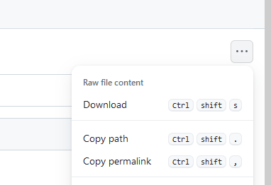
You can download the data from Github by opening the page for the data you want to download and clicking the 3 dots in the top right:

As mentioned earlier, there is a chat available to get support from other people doing this course and teachers. Each exercise has its own channel where you can ask questions about that specific exercise.
You can find the chat here: https://teams.microsoft.com/l/team/19:[email protected]/conversations?groupId=713525aa-e19b-4ba5-9491-cba5bcfc17be&tenantId=fa6944af-cc7c-4cd8-9154-c01132798910
This is only relevant for Tampere University students completing this course for credits.
The Moodle environment is where you will submit your reflections and map outputs, as well as complete some quizzes. If you have enrolled to this course on Sisu but have not been added to the Moodle environment, please contact the person listed as responsible on the Sisu page for this course.
This course is continuously developed and we would really appreciate any feedback you have for us! This could consist of issues you run into, but also things you think could be done better, every piece of feedback is welcome.
Everyone can give feedback through the chat, and students can write feedback in the feedback form.
This course was made by Rowan van der Kaaden and Jonathon Taylor.
Based on work and with help from:
- Muukkonen, Petteri S
- Jylhä, Markus J H
- Arosuo, Haikku I
- Ylinen, Kirsi M S
- Todorovic, Sara
- Leppämäki, Tatu
- Väisänen, Tuomas
- Ratvio, Rami
- Kujala, Sanna
- Ehnström, Emil
- Sarjakoski, Sakari
- Riipi, Paula
- Willberg, Elias
- Bergroth, Claudia
- Okkonen, Pasi
- Conenna, Irene

