-
Notifications
You must be signed in to change notification settings - Fork 58
geographic map
k3b edited this page Aug 25, 2015
·
27 revisions
 Pick an area from a Geographic-Map
Note: The geograpic data in the map come from openstreetmap servers and is cached on the android device. You need an internet connection to download the data.
You can reach the Geographic-Map via
- the "map symbol" in the Gallery-View
- the "location picker" in the Filter-View
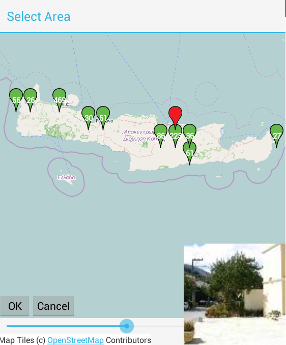
- The geografic map shows markers
 at places where photos were taken.
 - The numer in the green marker indicates how many photos belong to the marker.
- Blue markers represent selected photos if Gallery-View is in multiselection mode.
- If you tap on a marker a photo belonging to the marker is displayed in the lower right corner
- Tap on the photo to hide it.
- If you tap somewhere in the map the "zoomin"- and "zoomout"-buttons become visible to change the map detail level.
- If you double tap somewhere in the map the map zooms in one level.
- If you swipe left/right/up/down you can change the current map area
- The "Zoombar" below the map can be used to change the current zoom level.
- The "Ok" button takes the current visible map area/zoomlevel to update
- which photos are visible in the Gallery-View
- lat/lon values are used in the Filter-View
- The "Cancel" button or the back button closes the map without affecting Gallery-View or Filter-View

English:
- Homepage
- Download
- Walk Through: Gallery, Filter, Map, Folder picker
- Overview
- How to search/find/filter Photos
- Gallery-View
- Geographic-Map
- Image-View
- edit properties (exif) of photo(s).
- Filter-View
- Tags
- Virtual Albums/Bookmarks
- Folder-Picker
- AutoProcessing Automatic rename/apply exif on move/copy
- Settings
- Backup to zip
- History
- Technical infos
- supported photo properties (exif,xmp,iptc)
- Intent API for other apps to use APhotoManager
- Howtos
- Protect-mode (Extended App Pinning): Limit photos a user can see
- geotag-multible-photos
- Incremental Photo backup
- Workflow: Camera + move + rename + exif(tag, geo) to pc
- pc android photo properties (exif) sync
- Remote Problem Analysis Create a Logfile
- Filter Drill Down: Working with Picker Show-In-New
- Android 10
Other languages:
- ar Arabic العربية
- de German Deutsch
- es Spanish Espanol
- eu Basque Euskara
- fr French Français
- id Indonesian Indonesia
- it Italian Italianio
- ja Japanese 日本人
- nl Dutch Nederlands
- pt Portuguese Português, Brasil
- ro Romanian Român
- tr Turkish Türk
- uk Ukrainian Українська
- zh-CN Chinese traditional 繁体中文
- zh-TW Chinese simplified 简体中文

